Recommended Walks
A free leaflet with these walks is available from The Foxhound Pub, the Fish & Chip Shop, the Shop/Post Office and the Church.
|
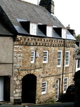
The Wicket |
A Village Walk (approx. 600m)Start the walk from the lower end of Red Lion Hill and enter Old Road, formerly the main route through the village from Yealmpton and Plympton. The main entrance to St. Mary's Church is adjacent to the small green at the end of Old Road. To the North of the Churchyard stands the late medieval 'Priest's House', a former parsonage and now two cottages.) Beyond the eastern end of the churchyard is the area known as The Park. Within this Park a grove of elm trees was planted in 1677 by Edward Fortescue of Spriddlestone, intended to be felled and sold for the relief of the poor of the parish. Continue through the village to the Post Office on the left and view 'The Wicket' just in the adjoining Elliott's Hill - a late 17th century building with 115 pigeon holes just below the eaves. Across the A379 from the Post Office there is a large magnolia tree at 'Singmore' which has magnificent blossom in early springtime. Proceed further along the main road. On your right stand 'Manor Cottages', of early origin and Manor House, built in 1911 but inheriting its name from an original Manor House, which stood at the western end of the village. 'The Foxhound', on the left stands opposite the entrance to 'Brixton House', a regency-style house built by an Exeter banker, Mr Collins-Splatt, in the early part of the 19th century. |
|
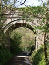
The Railway Bridge |
Torr - Combe Walk. Footpath Nos. 4/5/20 (approx. 2½miles -- 1¼ hours)From the centre of the village, walk the pavement beside the A379 towards Plymouth. A signpost indicating the 'Erme-Plym Trail' points across the road to Mill Lane. Follow the lane for 150 metres to Public Footpath No. 4 sign. Cross first an ancient stone stile and then a modern one. The path is well defined, running parallel with Mill Lane between a wire fence and the hedge. Exit this section over a wooden stile and down steep stone steps back into Mill Lane. The walk then continues left downhill to a railway bridge. Passing under the bridge continue downhill to Cofflete Creek with its tidal ford and ancient double arched footbridge. Keep to the tarmac road, ignore the 'Erme-Plym Trail' signpost and continue to the hamlet of Brixton Torr, where Footpath 5 begins. On the right at Half Acre Cottage bear right and pass between 300 year-old properties to an iron kissing gate passing over a stream leading to a field. Cross the open space to another iron kissing gate leading to a tunnel under the former railway line, which was used as an air raid shelter by Plymouth people at night in World War 2. Pass through a third iron kissing gate and turn right into a green lane. About 100 metres along on the left is Footpath No. 20 signpost and a stile entering a field. The footpath follows the hedge and is clearly signed towards the hamlet of Combe, where the path exits at a lane beside a World War Two air raid shelter. At this point either complete the walk by continuing up the hill to the A379 and turning right to the starting point in the village. Or, an alternative is to turn left to extend the walk, passing the thatched Aylescombe cottage on the right and continuing along a green lane to a Public Footpath No. 21 sign. There, climb up a slight ramp onto steep wooden steps leading down to a field. Again the path is well signed to the road. Turn right to pass Otter Nurseries and rejoin the A379. Turn right to return to the village. |
|
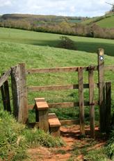
Stile before Tapps Lodge |
The Gorlofen Walk. Footpath No. 10 (approx. 2½ - 3 miles --- 1½ hours)Start from the Green by the Church. Turn into and proceed through Old Road. Follow the 'Erme-Plym Trail' sign across the road into Woodland Drive. Continue to the far end, then through the kissing gate. Go straight across the field and over the next stile. Keeping to the left of the field, you then will see a view of the isolated Tapps Lodge. Continue down the steep hill, over the stream (Silver Stream) via the bridge to the next stile. Keeping the hedge on the left, go towards the woods where there is an old lime kiln. Turn left through the field opening, keeping the woods on your right until you pass through another field opening. Follow the sign indicating a straight walk across open fields and passing two BT posts. Descend the hill, keeping close to the copse on your right, then climb over the stile into the woods. Follow the path to the steps into the lane. Ahead are Gorlofen House and Silverbridge Barns. Turn left up the lane. At the cross roads turn left and continue past Woolaton House and barns on the left. At Woolaton crossroads carefully cross the busy road into the lane opposite. Take the third gateway - (signed Footpath No. 9) - and walk diagonally across the field to the kissing gate leading to Cherry Tree Drive. Cross the road and follow the footpath sign down the steps past Tuscany's Club. Walk down Legion Lane and return to the Green by the Church. |
|
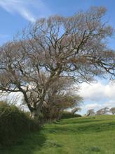
On Footpath 26 |
The Estuary Walk. (approx. 2¾ miles -- 1½ hours)From the village centre, follow the A379 towards Plymouth. Shortly after crossing Lodge Lane, look for the 'Erme-Plym Trail'sign pointing across the road. Cross the road with care and follow the sign direction down Mill Lane. Enter Footpath 26 over the wooden stile to the right of the gate to the house and cross a second stile in 20m. Follow the wide path between hedge banks to the stile giving access to a field. Cross the field making for a stone wall and gate with a stile by an ash tree. Cross stile and follow path keeping field boundary on the right to join Steer Point Road - turn right. Follow the road past cottages on the left to the entrance to the Brickworks. Opposite the Brickworks entrance, turn off the road through an iron kissing gate. Follow the 'Footpath 30' sign and continue on the path bearing left. Keep right at a bend ignoring a private path leaving left. At the next fork, there is a 3-way signpost. Footpath 30 continues to the right going to the estuary. A view of the creek appears on the right and keeping right gives attractive views down river towards Newton Ferrers, with boat moorings and Steer Point Lodge on the right bank. The main path is close to the shoreline through trees. Continue, keeping to the right of a small field, to an old gate which leads to a bridge over the former railway line. Do not cross the bridge but turn sharp right along the top of the railway cutting. At the top of a flight of steps there is a view of the estuary and the remains of Cylinder Bridge. Descend the steps to rejoin the alternative route along Footpath 31. Turn right and in approx. 150m follow the arrow on the signpost to the left up the bank out of the railway cutting. The creek and the railway embankment appear on the right. At the top of the slope, there is a waymarker post. Follow the path through trees to a stile, enter the field and keep to the right along the fence. At the end of the field, pass through the kissing gate turning left up the road to pass the water treatment works. As the road levels out, a view of Kitley House opens to the right. The road dips and passes Winston Cottages to the right and left (note the interesting house numbers!) The road climbs and passes under a bridge which carries the former driveway from Brixton Lodge to Kitley House. Continue straight on past modern houses to rejoin the A379 and turn left back into the village. |
|
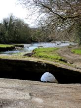
Cofflete Creek |
Cofflete Creek to Hollacombe Walk -- Footpath No. 2 (approx. 5 miles- 2¼ hr.)This walk begins at Cofflete Creek and is a continuation of the 'Erme-Plym Trail'. To find the starting point, follow the directions from the village described in Torr - Combe Walk ( to Torr Bridge ). The signpost Footpath No. 2 directs away from the Creek up a steep incline through woodlands for about 100 yards, where steps lead to a stile. The path is clearly marked and defined by a wire fence on the left and hedge to the right. Crossing another stile leads into open countryside where a succession of signs and stiles guide through farmland. Climb over an ancient stone stile and go down steps to come to a narrow lane with Barton Cottages facing. Walk the lane to the right for about 100m to a junction in the hamlet of Spriddlestone. A signpost directs through substantial stone pillars supporting an old iron gate into a long green lane towards Spriddlestone House. The lane ends at a gate marked 'Private' with a Public Footpath signpost to the left. Climbing the stile the path is waymarked across the meadow, which has a stream flowing through the middle, marking the boundary of Brixton with Wembury. To continue the walk, pass through Hollacombe Woods until a sign is seen directing one towards steps on the hillside. At the top of the steps follow the path to the Wembury road -- turn right. Walk the pavement to the speed de-restriction sign, to find a footpath behind the hedge running parallel with the road. About 100 yards along the path, a stile in the hedge returns to the roadside. Here a grass verge is walked to a crossroads (Ridge Cross), where a signpost indicates Spriddlestone. Turning right at the sign follow the road to the A379 at Chittleburn Cross, from where Brixton is signposted. Alternatively a quarter of a mile along the road from Ridge Cross, go right into the hamlet of Spriddlestone and rejoin the outward footpath route at Barton Cottages. |
Silverbridge WayThis permissive path was opened July 2013. Start as for the Gorlofen Walk (Footpath 10) and exiting Woodland Drive via the hunting gate turn right onto Silverbridge Way following the signpost. Continue down the path, which leads directly to Yealmpton village, through the fields alongside the main road (A379) via a bridge over Silver Stream. Just before the bridge on the Brixton side Silverbridge Way is joined by Footpath 16 on the left which can be followed across the fields to join with the Gorlofen Walk. There is an information board on the bridge and 2 'Mag' posts on the route for walkers of all ages to examine items of interest found along the way under a permanent magnifier. Tree trunk seats are also located along the route. |